Projects Overview
Nimba Licence (MEL 7012725)
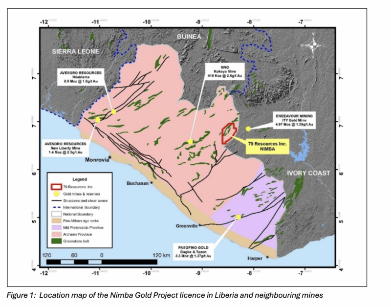
The Nimba mineral exploration licence (MEL7012725) was granted on the 23 January 2025 for an initial three year period of tenure. Covering an area of 827 square kilometres, the licence is located some 40km south west of Endeavour Mining’s 5-million-ounce (“Moz”) Ity Gold Mine in neighbouring Cote D’Ivoire (Figure 1).
Review of Nimba licence Exploration
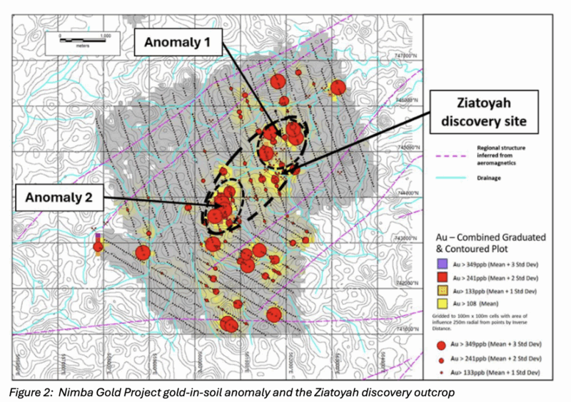
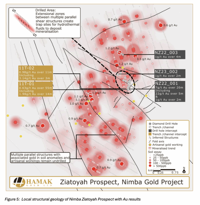
Following detailed soil, trench/channel and rock chip sampling, in late 2022 the Company discovered an outcropping (at surface) gold mineralized metadolerite unit (greenstone package) at a site called Ziatoyah, which was subsequently drilled and returned a best result of 20m at 7g/t Au near surface and under the mineralized outcrop.
Associated with this discovery outcrop is a gold-in-soil anomaly which extends over a 5.7km by 1km northeast trending area (Figure 2). Streams that dissect the anomaly are exploited by artisanal gold miners, suggesting that the extent of the anomaly may be related to an extensive hard rock gold deposit.
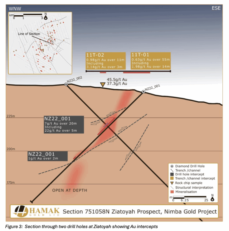
Drilling at Ziatoyah intersected a zone of strongly foliated dark grey metadolerite with weak to moderate levels of dissemination and smeared pyrite mineralisation of between 1 and 5% over the overall rock mass. Significant gold mineralisation was returned between 28.0m and 48.0m returning 20.0m @ 7 g/t Au, with a high-grade zone returning 5.0m @ 22 g/t Au. Preliminary modelling suggests that the ore body follows the foliation and is cut and dislocated by shallow dipping N-S faults (Figure 3):
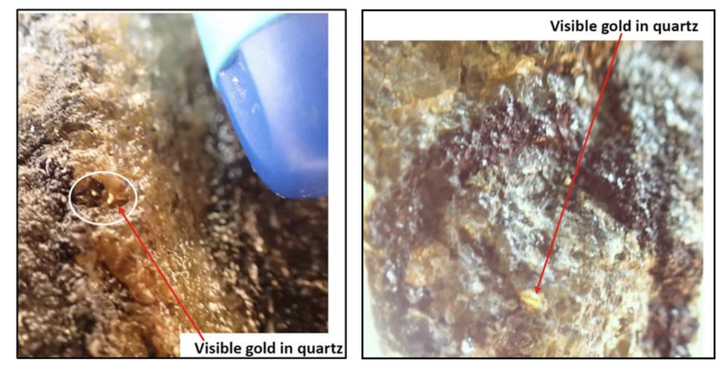
The gold mineralization intersected at Ziatoyah suggests that the gold occurs as free grains within disseminated pyrite. Microscopic free gold has also been identified at numerous points within the mineralized sections of the drill core.
Visible Gold in Metadolerite Unit
The Cestos shear zone, located along the southeast boundary of the Nimba licence, is defined by a major NE trending dislocation zone (Figure 4). Historical aeromagnetic data implies a pattern of southwest to westerly trending secondary structures branching off this shear zone. Such secondary faults, or splays, may have created extensional zones for the focus of hydrothermal activity responsible for gold mineralisation.
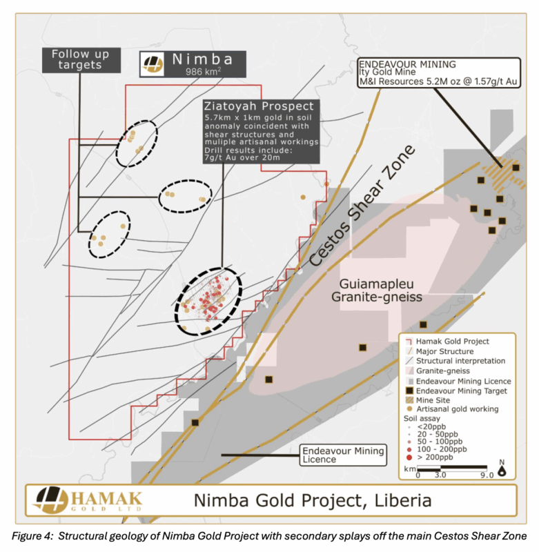
Following a review of all exploration data, it is now believed that regional scale folds and probable associated parasitic folds should be considered the primary exploration targets across the Nimba License. As a result, the Company undertook additional detailed field mapping to become more conversant with the stratigraphic, lithological, alteration patterns and structural controls to the mineralisation at the Ziatoyah prospect. A summary of the soil sampling, trenching and drilling results are shown in Figure 5 along with inferred structures and possible fold axis.
Future Work Programme
Following the signing of the Joint Venture Agreement with First Au Limited, a drilling programme, supported by detailed structural mapping, will be undertaken using two recently procured drill rigs. The objective is to not only establish a maiden resource but also obtain a better understanding of the structural controls to the gold mineralisation which can guide future drill campaigns and resource delineation.